")
")
")

3 San Lucano (752 m a.s.l.): The "Borai" and the importance of faults in outlining the landscape of the San Lucano Valley.
The church of San Lucano is located at the foot of the Boral di San Lucano from which it is protected from landslides and avalanches by a distinctive stone structure.
The church is dedicated to the alleged Bishop of Sabiona, the "Apostle of the Dolomites", who apparently carried out his pastoral duties in this valley between 430 and 440 AD.
The first historical evidence dating back to the fourteenth century speaks of a small oratory; there is mention of a small church with a single nave and two altars in the archives from the sixteenth century. The church was rebuilt and consecrated in 1835 after having been destroyed by an avalanche. It was damaged again during the flood of 1966 because of its proximity to the riverbed of the stream Tegnàs which swept away part of its artistic heritage. Some of the artworks have been saved, the one worth mentioning being a canvas from the 17th century whose authorship is attributed to Francesco Frigimelica "Il Vecchio"; the painting depicts a Madonna with Child together with St. Lucan and the Blessed Vaza in front. Vaza's humble peasant attire reflects women's apparel from the 17th century in Agordo and thus represents an important historical record.
OPENALP LINK: Church of San Lucano (italian)
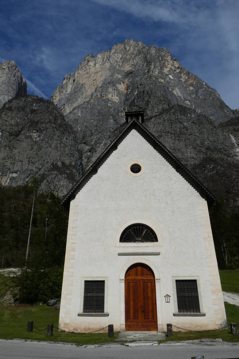 Church of San Lucano with Boral di San Lucano in the background (photo DG).
The "Borai" and the importance of faults in outlining the landscape of the San Lucano Valley.
The "borai" are deep ravines that run along faults and fractures and are quite common in the San Lucano Valley. The most famous of them is the so-called Boral della Besausega winding across a mountaineering route from Forno di Val to the first Pala di San Lucano.
Boral di San Lucano is the epitome of the dolomitic ravine - to the east it is flanked by the solid walls of the Seconda Pala and by the long vertical ridge of the Terza Pala to the west. With a depth of up to 800 meters and less than 400 meters wide, it is a staggering crevice that is impossible to negotiate by conventional climbers, and is deemed an extraordinary undertaking even by the most experienced ones.
The deep carvings on the Pale di San Lucano are the result of a phenomenon called selective erosion. The movements of the Triassic faults, which in turn were augmented by the Alpine Orogeny, led to the fracture of the rocks that are susceptible to erosion to a higher degree compared to the dolomitic massifs; the activity of external factors, such as freeze-thaw cycle, surface runoff and karsting, are more effective along such rocks.
Subvertical tectonic structures as is the case with the "borai" of the Pala-Group and Agnèr, are characterised by even more intense erosion because of the greater force created by the steep relief; the latter facilitates the removal of the disintegrated debris along the ravines. On the other hand, detritus along less tilted fault is planes is difficult to remove and tends to cover the structure thus keeping it from erosion; the effect of accelerated erosion occurs regardless of the extent of rejection between the blocks.
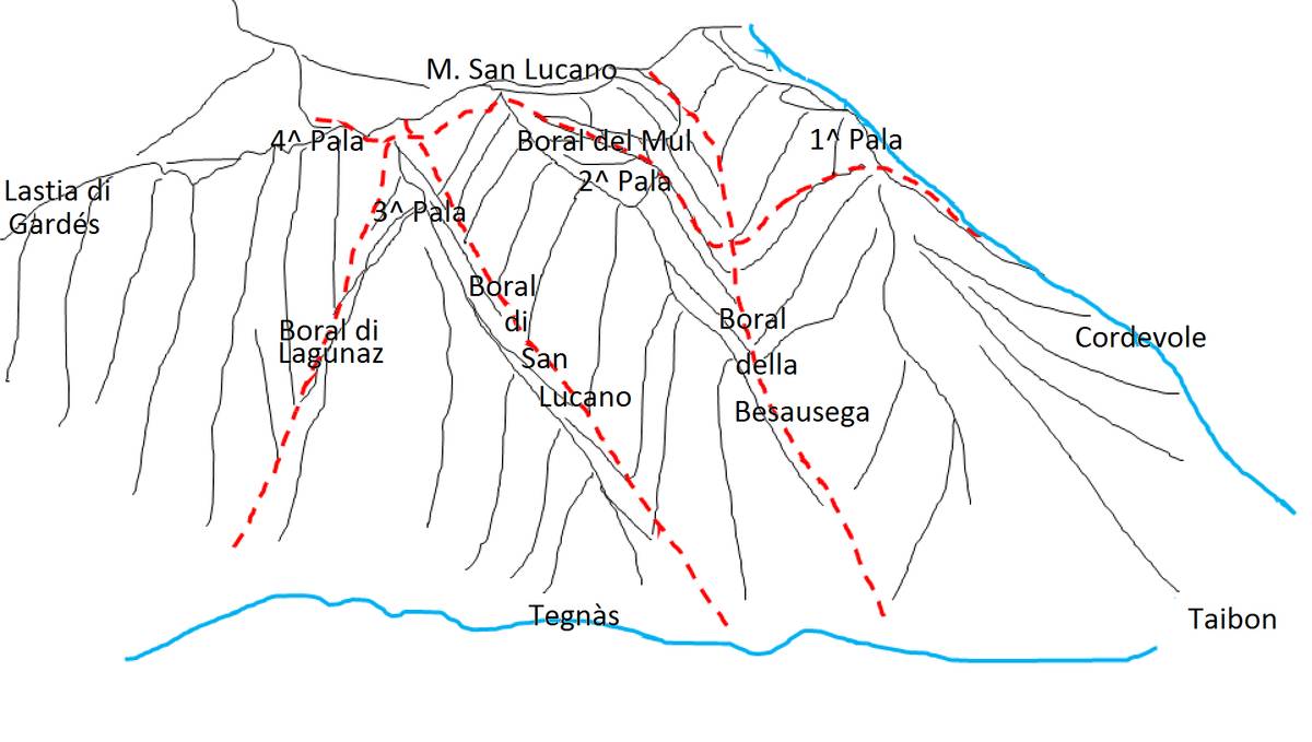 Illustration of the fault system which strongly influenced the erosive processes that shaped the landscape (ill. D.G.).
Livinàl dell’Acqua and source of Scafa-San Lucano
From the church our journey continues along the road between the stream Tegnàs and the large boulders coming from the landslide scattered at the foot of the Pala-Group. At the second picnic area located 700 m from the church we can have a short break enjoy the view to the boral known as Livinàl dell'Acqua. The ravine is called Livinàl because of the gigantic avalanches tumbling down during snowy winters from the hanging glacier cirque called “la Scudela”, or "bowl" in English, which hosts a small perennial snowfield. La Scudela is nestled between Spiz della Lastia and Spiz d'Agnèr and is dominated by two quaint peaks - i Denti di Satanasso - whose shapes clearly speak of the influence of selective erosion.
The prominent karst spring of Scafa-San Lucano is clearly visible on the left side, at the foot of the ravine. The source that flows from the rock at an altitude of about 885 metres above sea-level is defined as a contact spring where permeable and impermeable rocks meet. This is a unique spot allowing us to directly observe the hydrogeological contact between the aquifer composed of the carbonate rock fractures from the Lower Schlern Dolomite, and the highly clayey aquiclude of the Werfen Formation. The flow of this moderate-sized spring has been constant throughout the years, with seasonal values ranging from several dozen to a few hundred litres per second.
Tegnàs's riverbed
The stream Tegnàs will be our steady companion for long stretches during our journey. Unlike most Dolomite streams, this waterway was seldom disrupted by man and has thus maintained its natural course. This particular feature rendered it the ideal sited open-air laboratory for understanding the underlying dynamics of fluvial processes. The research which began ten years ago is still in progress and is carried out by the CNR of Milan in cooperation with IIS “U. Follador ”of Agordo.
The study of the water flow of the stream Tegnàs has revealed an anomalous hydraulic behaviour of the San Lucano Valley. Under normal conditions the water coming from the upper part of the basin which includes Val d'Angheràz and Val Bordina, is partly absorbed by the gigantic alluvial bed in the Mezzavalle area with a thickness of 150-200 meters and 300 meters wide, only to resurface further downstream. The reason for this anomaly is associated with a watertight underground septum created by a moraine or a deep slope collapse acting as a regulator of the outflows by dividing the basin into two parts; there are higher and variable flow rates with large amounts of loose debris upstream, whereas downstream is characterised by smaller and contained outflows with little sediment transport. Naturally, this hydraulic behaviour is not applicable to such extraordinary events as the 1966 flood or the storm Vaia which led to the complete disruption of the riverbed.
We reach Mezzavalle after another half a kilometre.
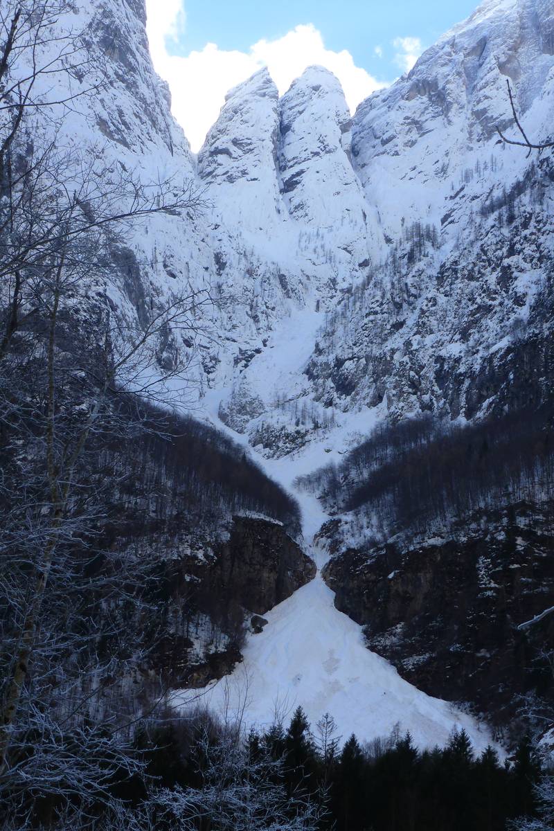 Livinàl dell'Acqua (cone's peak height of approx. 900 m) in February 2014 which turned to be a particularly snowy year. The thickness of the snow in the avalanche cone was estimated at around 50 meters, part of the snow was preserved until the following winter. At the top, the two particular peaks called Denti di Satanasso (photo DG).
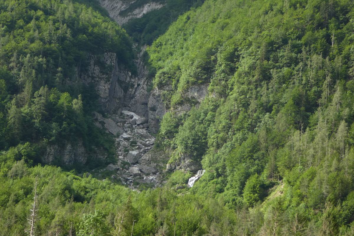 The lower part of Livinàl dell'Acqua with the water spring Scafa-San Lucano, the rocky wall is carved in the Contrin Formation (photo DG).
Download
 |
Download the full content of the information panel number 3 (pdf format) |