Trail description

Posted in Earth trail

Earth Trail: geology, local history and the use of rocks by man.

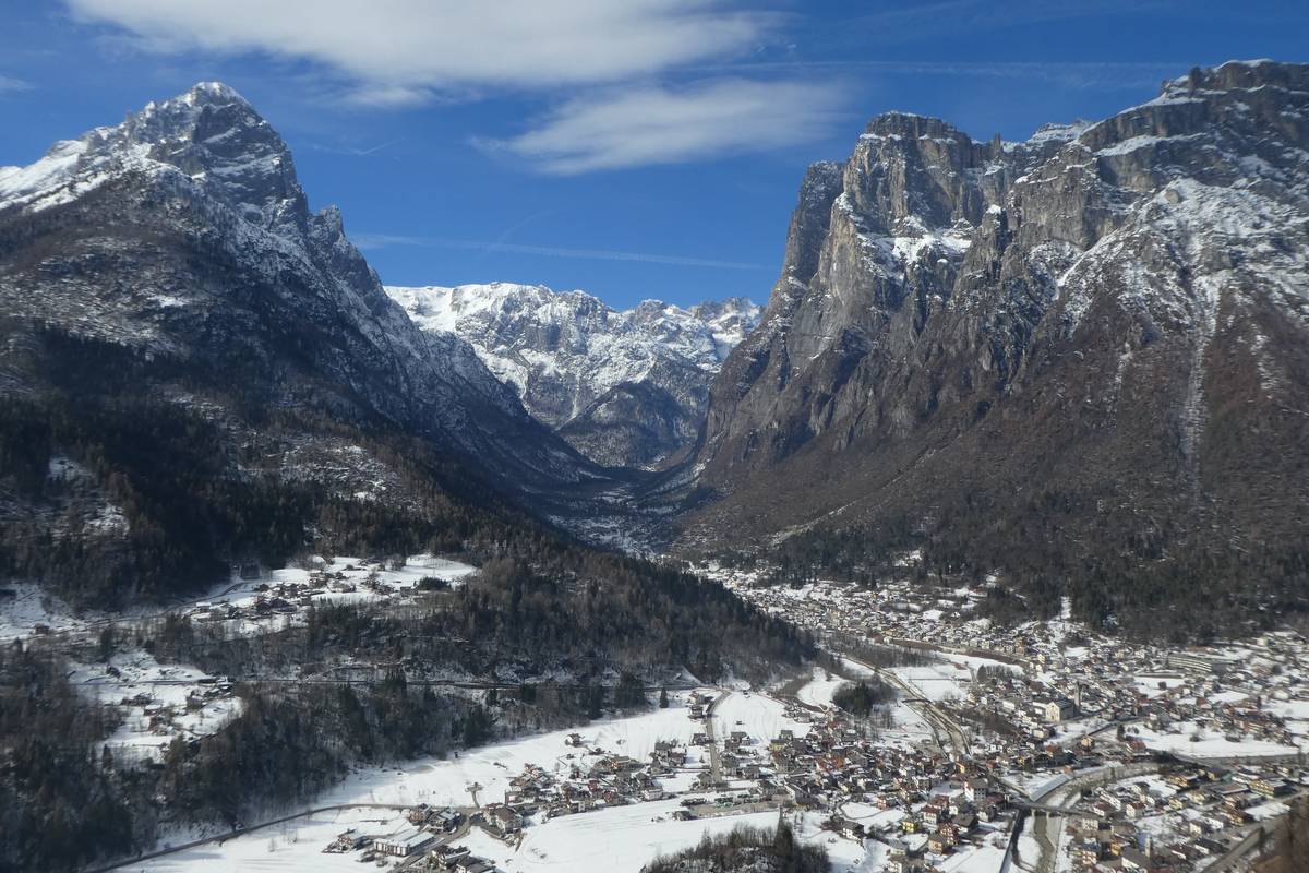
It runs mostly along the valley floor and is divided into the following tracks: San Lucano (Panel 3), Mezzavalle (Panel 4), La Calchera (Panel 5), Sentiero Cozzolino (Panel 6), Landslide of Prà and Lagunàz (Panel 7), Col di Prà (Panel 8), The "U" section (Panel 11), Pont (Panel 12)

Departure: Taibon Agordino
Length: 9 km;
Difference in altitude: about 550 meters
Travel time (on foot) a whole day.

4- Mezzavalle

Posted in Earth trail

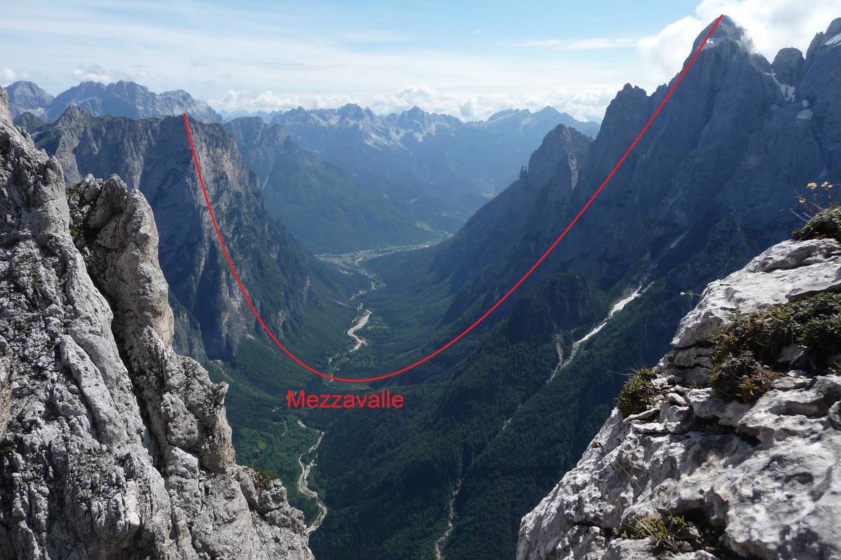
4 Mezzavalle (776 m a.s.l.): The deepest part of the valley

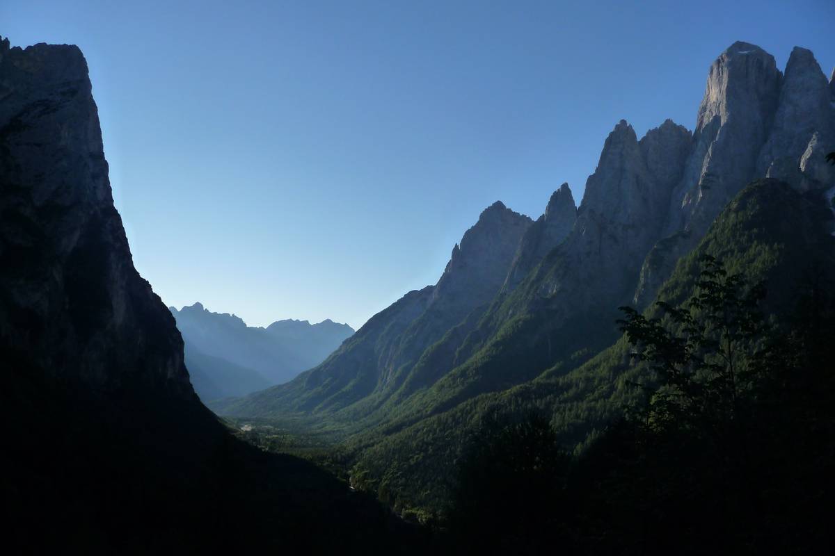
At an altitude of 776 metres above sea level, Mezzavalle is situated at the bottom of the narrowest and deepest glacial valley on the planet, almost 2100 metres lower than Mount Agnèr (2872 m). Recognised as the greatest U-shaped valley, it descends from Mount Agnèr right to the valley’s floor, only to rise up again to the top of the Terza Pala di San Lucano.

There exist bigger glacial valleys all over the world but because of their width, the U-shape, so typical for the glacial valleys, is almost unrecognisable; there are even narrower valleys, however, too small and less deep.

Seismic surveys conducted in the area using ultrasound to help scientists better understand the deeper structure of the Earth, have allowed us to rebuild the development of the rocky substrate buried underneath. The results reveal that the rock is located 200 metres deeper than the ground level, meaning that the U-shape is even more profound than previously thought.

Part of the San Lucano Valley passing through Mezzavalle (775 m asl) between Terza Pala (2354 metres above sea level) and Mount Agnèr (2872 metres above sea level) through “el Cor” in Pale del Balcon (photo DG). Part of the San Lucano Valley passing through Mezzavalle (775 m asl) between Terza Pala (2354 metres above sea level) and Mount Agnèr (2872 metres above sea level) through “el Cor” in Pale del Balcon (photo DG).

5 - The "Calchera" - The Limekiln

Posted in Earth trail

5 The “Calchera” (800 m a.s.l.)

How lime was made

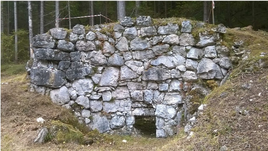
Limekilns once played a significant role in local construction and constituted an important source of revenue for the inhabitants of the valley, as the materials involved were easily found on site. The stones necessary for the production of lime were skilfully extracted either from the landslide debris that surrounded the foot of the “Pale” walls or along the Tegnàs riverbed. Bundles of broadleaf branches (beech, hazel, ash and hornbeam) were used as fuel; some of it was leftovers from firewood, or from the charcoal kilns.

Calchera, or lime kiln, built with dolomite ashlars.Calchera, or lime kiln, built with dolomite ashlars.

6- The Cozzolino Trail

Posted in Earth trail

6 The Cozzolino Trail (approximately 900 m a.s.l.) - A key to understanding the geological structure of the Dolomites

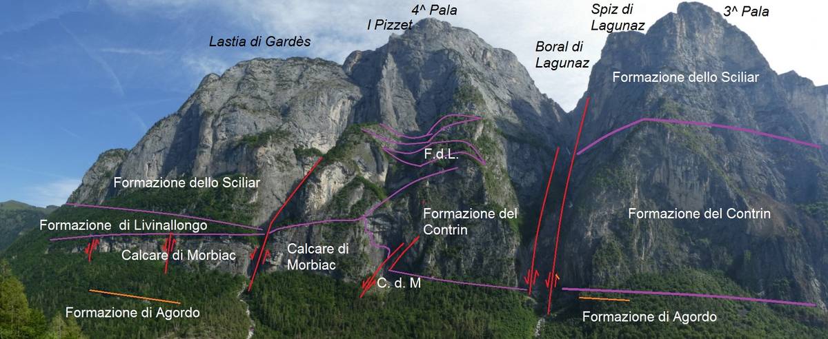
The view from this spot enables us to grasp the geometric parameters between several formations, namely the Contrin carbonate platform of the Anisian together with its adjacent Morbiac Limestone with its typical lagoon environment, and the Ladinian escarpment from the Schlern Formation which protrudes on the attached marine basin in the Livinallongo Formation.

Panorama towards the Quarta and Terza Pala di San Lucano with indication of the geological-stratigraphic situation (photo DG).Panorama towards the Quarta and Terza Pala di San Lucano with indication of the geological-stratigraphic situation (photo DG).

7 - The landslide of Prà and Lagunàz

Posted in Earth trail

7 The landslide of Prà and Lagunàz (812 m a.s.l.) - The chronicle of a death foretold

This is how Ottone Brentari described this location in his “Guida Storico-Alpina di Belluno – Feltre – Primiero – Agordo – Zoldo”  from 1887:

“Lagunàz is a delightful bundle of half a dozen cabins on the banks of the stream; it is surrounded by meadows with scattered cherry trees and huddles right under the imposing crack inside the walls of the Pale. The road finishes at Prà and represents a row of houses under the rock. The fields and the meadows that grow corn, beans, rye and potatoes have been ruined for the most part by the flood of 1882. There is a tiny church with a room attached that is used as a school. The village pub serves wine and brandy."

The picture painted in our mind's eye is completely different from the situation now largely because of two occurrences. The most important event is certainly the landslide that fell in the night between the 2nd and the 3rd of December 1908 from Quarta Pala di San Lucano and to be more precise, from Pizet at an altitude of approximately 2100 metres. The rocky mass plunged 1300 metres into the valley floor and swept away the hamlets. The second and more subtle phenomenon is the exodus from the mountain and the abandonment of the subsistence agriculture practiced in the Dolomite valleys.

The landslide of Prà and Lagunàz is characterised by a special and poignant history. Several Viennese geologists studied the Pala-Group of San Lucano in the mid-1800s, when Agordino was still part of the Kingdom of Lombardy-Venetia; they identified an open fissure that ran parallel to the slope, which at the time was represented as Cime di Ambrosogn on the maps (now PIzet).

The inhabitants of the valley were forewarned about the imminent danger and the authorities ordered their relocation to Listolade, near Roch de Buos, at the foot of Mount Framont. The villagers decided against the move, however, especially when, on May 11, 1865, a landslide from Lastia del Framont collapsed in the vicinity of the very spot chosen as their new home, causing two victims.

With the arrival of the Kingdom of Italy with its “usual geological sensibility”, with which our ruling class was distinguished, the potential danger of a landslide was forgotten and the inhabitants of the valley continued with their daily lives until that tragic night, when part of the overhanging pillar of Pizzet detached suddenly; the pillar appeared to be solid and was composed of Schlern Dolomite - in reality it was crisscrossed by faults and fractures. A rocky mass of approx. 200000 cubic metres collapsed and hit the rocky ridge situated to the east of Van del Pez; it then split in two parts and the shattered material plummeted towards the two hamlets, causing 28 victims.
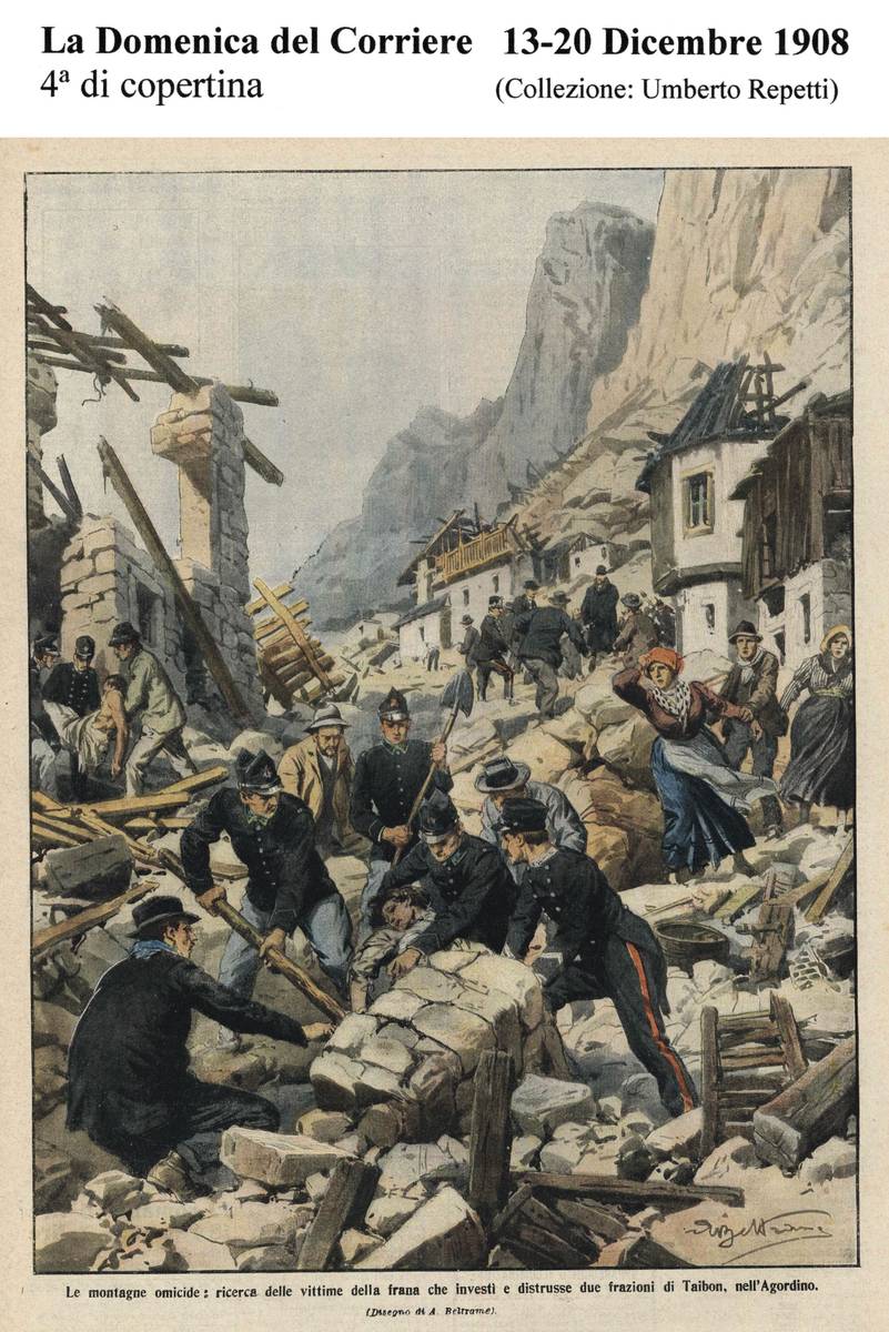
Back cover of Domenica del Corriere, 13-20 December, 1908 where the tragedy of Prà and Lagunàz was depicted by Achille Beltrame in watercolour (Umberto Repetti collection).Back cover of Domenica del Corriere, 13-20 December, 1908 where the tragedy of Prà and Lagunàz was depicted by Achille Beltrame in watercolour (Umberto Repetti collection).

8 - Col di Prà

Posted in Earth trail

 8 Col di Prà (843 m a.s.l.) - The North Edge of Agnèr

"... the grandiose architecture of the Dolomites surges with terrible force - looking form the bottom of the valley, one has to twist one's head upwards in order to take it all in. Monte Agnèr looms with its peak of a kilometre and a half; in front and beyond the more modest but by no means less charming stream are the walls of Pale di San Lucano. Less than 2900 metres high, the peak itself doesn't amount to much in terms of height. But what other Alpine cathedral can boast such apse? When it blazes in the setting sun and the pale clouds begin to engulf it slowly, one is charmed into believing that such sight could not possibly exist."

Dino Buzzati, Cordata di tre (A Roped Team of Three), in “Corriere della Sera”, June 23, 1956.

11 - The “U-shape” section

Posted in Earth trail

11 The “U-shape” section (1088 m a.s.l.) - Panoramic view between Terza Pala and Agnèr

Slightly upstream from the crossroads between the CAI path and the military road to Pont, the visitor can admire a postcard-perfect portion of the San Lucano Valley with its quaint U-shaped profile, tucked between the Terza Pala and Agnèr. The section is 3000 metres wide and 2100 metres deep.

It has a slightly asymmetric build, its left side being steeper as its strata are running counter to the slope, whereas its right side is less inclined thanks to its dip slope strata and the landslide deposits at the base.

A picturesque view over the San Lucano Valley with its classic “U” shape is revealed just before reaching Pont; Pale di S. Lucano on the left and Agnèr on the right (Photo DG). A picturesque view over the San Lucano Valley with its classic “U” shape is revealed just before reaching Pont; Pale di S. Lucano on the left and Agnèr on the right (Photo DG).

12 - Pont

Posted in Earth trail

12 Pont (1149 m a.s.l.) - The quarries and the Moena Formation

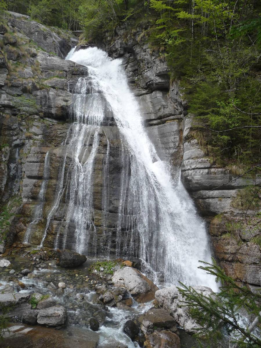
There is a beautiful waterfall carved in the Morbiac Limestones in Pont - a dark grey marly limestone with a nodular appearance deposited in the Late Anisian in shallow water environments or in marshy areas.

A stroll along the left bank of the stream will bring us to the remains of a quarry abandoned a long time ago. In the immediate post-war period, a series of small quarries, some of which located underground, supplied the “Black Taibon Marble”; it was a dark bituminous limestone of the Moena Formation. Machine remains, half-finished blocks and signs left on the stone by cutting with rotating wire are still visible in the area. The quarries emit a strong sulfur smell and there are sometimes hydrocarbons drip from the dark rock.

Thef Pon waterfall - a skip of about 30 metres carved out of Morbiac Limestone layers (photo DG).The Pont waterfall - a skip of about 30 metres carved out of Morbiac Limestone layers (photo DG).

PROJECT PARTNERS


universitat innsbruck

UNIVERSITY OF INNSBRUCK


Logo IIS Follador

ISTITUTO DI ISTRUZIONE SUPERIORE
"U. Follador - A. De Rossi"


circolo cultura e stampa bellunese

CIRCOLO CULTURA E STAMPA BELLUNESE