The mining activity in the San Lucano Valley

Posted in Mines

Mining from its origins to the 18th century

As in almost all of the Agordino region, a fairly flourishing mining activity took place in the San Lucano valley, with dynasties such as the Crotta family and others of lesser fame as protagonists.

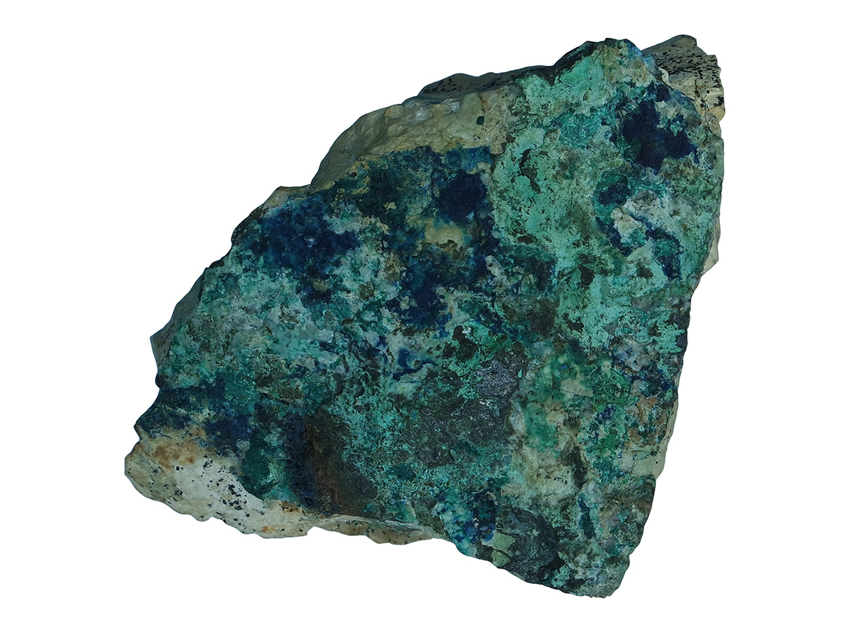
Because of its unique geological and geomorphological characteristics, the valley was significant in the past both from mining and mineralogical point of view; its mineralogical value is still appreciated by experts in the present. The area is affected by the contact between volcanites and sedimentary rocks: this combination gives rise to numerous collectible minerals such as heulandite, analcime, quartz, amethyst quartz, chalcedony, calcite, etc. and minerals of industrial interest such as pyrite, chalcopyrite, bornite, native copper, siderite, etc.
It was precisely the occurrence of siderite that fostered the development of the mining sector in the area.

It is believed that mining activity in the San Lucano Valley and in the Agordino goes back to antiquity, with some of the mines being already active during the time of the Romans. Such assumptions are based on historical data, such as the documented existence of an iron refining furnace which processed iron ore from Fursil and operated between 1394 and 1509 in the San Lucano valley.

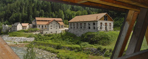
The first real recorded document of such activity, however, originated from the year 1666. The Venetian-born Costa family settled in Taibon and in Forno di Val, at the mouth of the San Lucano Valley during the thirteenth century; their goal was to exploit the hydraulic energy of the Tegnas stream as well as to process the iron ore from the mines of the San Lucano Valley and its surrounding areas.

Their arrival gave rise to a flourishing iron craftwork. Not many records bear witness of the mining activity between the fourteenth and sixteenth centuries, which can likely be explained by Agordino’s troubled history during this period. The beginning of greater political stability and a major improvement of the living conditions in the Agordino during the 1600s, marked a more detailed written record on the mining concessions for prospecting in the area; the beginning of such written tradition implies a surge of mining activity in the valley of San Lucano as well.

Mining research flourished in the San Lucano Valley during the seventeenth century mainly due to two reasons: abundance of metalliferous mineralization deposits and the resulting need to satisfy the growing demands of the Republic of Venice. Because of the unclear descriptions from this time period, the exact location of the mines remains unknown: the indications cover a vast area, and in addition the sites have undergone numerous environmental and morphological changes over the centuries; last but not least, the names of the various places known to modern cartography have either disappeared or have been changed.

The locations indicating the ancient mines were positioned in part using ancient indications, reconstructed by consulting "News on the mining industry in Venice under the rule of the Republic”, by E. Oreglia (1915), and partly with the contribution of geological data retrieved nowadays - mineralised traces - which can corroborate the authenticity but can by know means give certainty.

Mining research in the twentieth century, last act

No new mining activities were recorded between 1748 and the autarchic period, when, as in the whole of the Agordino territory, searches were reopened on the once known mine sites. Many of these presumably corresponded to the old mines mentioned above. With ten concessions granted by the Republic of Venice in the seventeenth and eighteenth centuries, the San Lucano Valley represented quite the intriguing area from mining point view and attracted the attention of many entrepreneurs from Belluno.

Among these entrepreneurs stands out the name of BC di Sospirolo, who on the 12th of October 1924 filed the first application for obtaining a prospecting concession in the municipalities of Taibon and Canale d’Agordo. The application was submitted to the Prefect of Belluno, who in turn forwarded it to the Royal Mining Department (CRM) in Padua. A map indicating the area in question was enclosed with the application. Following further inquiries on behalf of the authority, a detailed report of the areas appointed for mining prospecting was issued on December 6, 1924. The report included a total of five locations: two sites in Malgonera, one in Valghere and other two in Campigat.

On the 28th of the same month B.C. submitted a new request for two further areas in Cesurette. The annual prospecting permits held by B. C. had expired in the meanwhile, and thus on the 4th of May, 1926 he submitted an application for renewal limited to the areas of Campigat 1 and 2 and Cesurette 1 and 2, while ceding those in the Malgonera area. As announced in his report from 11 January 1926, B.C. filed a prospecting request in an area which had not yet been taken into account; its presumed location is the area of the Reiane Valley. Perhaps the entrepreneur associated the area with the old iron mines of the Crotta family and was intent on exploiting not only the copper but also the iron ores. The prospecting permit in the Campigat area was sold to the L.S. & C company on the 14th of June 1926. The latest record of a granted prospecting permit for the area dates back to the year 1929.

This is how the mining industry in the San Lucano ebbed away - almost as a footnote to its rich history as Nature took over the areas where man has toiled for many centuries. Nowadays the real mine is the entire valley with its uniqueness from geological and landscape perspective. Its stunning beauty represents a secure investment as tourist destination for the inhabitants.

Ancient mines of the San Lucano Valley

Posted in Mines

1. July 21, 1672 concession - Crotta family

On 21 July 1672 a concession was granted to a member of the Agordino family at the time most influential, the Crotta:

“In the territory of Agordo, mountain of Malgonera. To N.D. Andreina Crotta and Companions. Busa sive minera; in the morning it borders the Stia di Val di Gardes, in the middle of Mount Valzere in the evening the Larese, to the north a place called Dapè”.

The quotation has a slight inaccuracy in fact the name Andreina is a probable transcription error, in fact it was the noblewoman Andreana Crotta, wife of Giovanni Antonio Crotta killed by some hitmen on 2 September 1654 hired by his brother Giuseppe Crotta, both owners of the richest area of the mine of Valle Imperina. Andreana was a woman of great entrepreneurial skills, and after the latter's death, she took over the reins of the family business, becoming the leader of the local mine dealers.

Unfortunately, the currently visible traces of the mining activity she managed have completely disappeared.

2. November 17, 1674 concession - A. Ferrara

On November 17, 1674 a concession is granted:

”In Monte Valicani on Col delle Gianese, in the Forno di Val Rule. To Andrea Ferrara qm. Antonio. Copper mine”.

3. September 20, 1675 concession - A. Polrizza

On 20 September 1675 the concession was granted:

”San Lucano Valley. To Andrea Polrizza and C. Copper mine; it borders Valle delle Fassine in the morning, Col delle Giasere at noon, Campi Gat in the evening and Pala del Cetta to the north”.

4. May 19, 1730 concession - A. Orsolin

On May 19, 1730, a new research investiture was issued:

“In the San Lugano Valley under the Val oven rule. To Antonio Orsolin and C. Copper mine, bordering Pala del Bech in the morning, Col delle Giasere at noon, Campigat, Val di Lastra and Val di Pares in the evening, Col del Bech, La Stia and Val di Gares to the north” .

5. August 3, 1666 concession - A.Pietroboni

On August 3, 1666 the Council of Ten invests Andrea Pietroboni with the research permit for a copper mine located:

In the relevance of Forno di Val under the Volpera mountain, in the territory of Agordo to Andrea Pietroboni qm Gasparo. mine to be named San Lucano, now showing a copper vein; it borders the mountain called Miel to the east, water called Tegnias at noon, Val Regane to the west, Volpera itself to the north[1]”.

[1] From “Notizie sull’industria mineraria nella Venezia sotto il dominio della Repubblica” by E. Oreglia

6. August 3, 1675 concession - A. Jachon

On 3 August 1675 the concession was granted:

“San lugano Valley. To Agostin Jachon and C. Copper mine, bordering Pian di Regrana in the morning, Col delle Gisere at noon, Pisandolo water in the evening and the Val that goes to the Forcella Bassa in the Val di San Lucan to the north”.

7. July 31, 1674 concession - A. Sasso

On July 31, 1674, a new investiture was issued:

“In the mountains of Valgesa under the Rule of Val di Forno. At Antonio Sasso & C. copper mine, Val di cancel, under Pra di Canal”.

8. January 11, 1672 concession - A. Messedin

On 11 January 1672 the Council of Ten issues a new investiture:

“In Val di S. Lucano, in Mount Valgar, a place called Campi Gatti, Regola di Taibon and Forno di Val, above the Villa di Jacon. To Francesco and brothers sons of Antonio Messedin and Compagni. Copper and other metal ore; it borders the Salto del Petoloto in the morning, south of the Salina coast, to the north in Cao de Chisurette, in the evening the Zof road”.

9. July,16 1676 concession - C. Michiel

On July 16, 1676, the last research grant of the seventeenth century was recorded:

“In Monte Pezzaine under the Di Val oven rule. To Ser Gerolamo Michiel. Copper mine; it borders water in the morning and noon in the evening in Pian di Pezzaine”.

 10.  May 28, 1743 concession - Z.A. Crotta

On May 28, 1743, a new concession is issued: “Investiture in N.H. Ser Zuan Antonio Crotta of all the buse indicating iron vein in the San Lazzaro Valley. It borders the peaks of Mosternà, Campigna and Val di Parne, up to Ponte”. 

Note that::

  • is granted to a member of the Crotta family, who had already owned iron mines in the valley in the past;
  • the investiture does not speak of a single research but of several mines, some of which are already in operation.
  • the toponyms used by Oreglia to indicate the location of the mines, according to him all in the San Lucano valley, do not appear in other investitures nor are they present today. The only exception is the toponym indicated as "Ponte" which could be interpreted as the current Pont location.
  • The denomination of the valley is San Lazzaro and not San Lucano.

It can be assumed that the investiture could be a continuation or extension of the previous concession. Following the concession of 23 May 1743, the Crotta family opened their business.

The former Falkenstein mining district near Schwaz

Posted in Mines

The former Falkenstein mining district near Schwaz - an underground access to dolomite rock

BASIC INFORMATION

ACCESSIBILITY: The former underground mining areas are not accessible; visitors can gain an insight into the underground dolomite deposits during their visit to the neighbouring show mines.
MUNICIPALITY: Schwaz
ADDRESS: Alte Landstraße
GEOGRAPHIC COORDINATES: 47.353672, 11.727441
PROVINCE: North Tyrol

DIRECTIONS: The Schwaz silver mine is centrally located in the Inn Valley and can be reached by car via the Inntal motorway A12 (exit Schwaz). At the next roundabout, take the exit in the direction of Wörgl. At the second roundabout continue straight on towards Wörgl and after about 1 km as you drive on the B 171, turn right into Bergwerksstraße. Turn either left into car park no. 2 after further 600 m, or right into the car park no. 1 after further 100 m. If you come by train to Schwaz, you can reach the show mine straight from the town centre by bus (line 1 or 2).

DESCRIPTION

The fahlore deposits near the city of Schwaz were mined during the Middle Ages in the "Schwazer Dolomit" (dolomite from Schwaz). This fact turned the city into a centre of the mining industry during a time when the mining sector was experiencing its blooming period, around the year 1500. The dolomite overburden brought to the surface was then processed into gravel and crushed rock. Even though various economic factors led to the discontinuation of ore mining in 1957 due to economic factors, not all underground activities were terminated altogether. A new cornerstone was thus laid to steer the transition from mining to an underground quarry in 1958. Due to its physical properties, the "black dolomite" extracted in the Wilhelm Erbstollen mine found its use in the production of asphalt pavements for road construction. The quarrying of dolomite rock in Schwaz ceased after the massive rockfall in Eiblschrofen in 1999. In close proximity to the disused gravel mine, is the show mine "Silver Mine Schwaz", which allows visitors to take the mine train into the 500-year-old Sigmund Erbstollen. Deep below ground, visitors can gain first-hand impressions of the underground deposits of dolomite, which used to be mined in the neighbouring and now no longer accessible Wilhelm Erbstollen.

The “black dolomite” of SchwazThe “black dolomite” of Schwaz

Dolomite in the mining site of Valle Imperina

Posted in Mines

BASIC INFORMATION

LOCATION

municipality: Rivamonte Agordino
address: Via Miniere
geographic coordinates: 46.257986, 12.042303

ACCESSIBILITY

  • wheelchair accessibility: visual impairment, accessible – motor disability, not accessible
  • recommended season: may-october
  • directions to reach the starting point: from the Regional Road 203 towards Agordo, just before the locality of Le Campe, go down to the parking lot of the Mining Center marked by a train engine

INFORMATION

telephone: 0439 3328
email: This email address is being protected from spambots. You need JavaScript enabled to view it.

DESCRIPTION

The dolomite had its widespread use in the construction works in Valle Imperina. In spite of the fact that the rock had undergone formidable tectonic thrusts in the past and is often densely fractured, large stone blocks from the Main Dolomite have been used for building, for instance in the construction of stone ovens, since the material could be retrieved easily with a vast outcrop stretching on the southern slopes of the valley.

The utilisation of dolomite can be found in the galleries of the mine, apparently originating from the Contrin formation (known in the past as "Serla dolomite), from the Valley of San Lucano, in the municipality of Taibon Agordino. As G. Vallenzasca stated in 1840: "The limestone that bears the scientific name dolomite is processed in this same valley. The large boulders are scattered unevenly over the gravel ground near the stream Tegnas, but most of all opposite the fissure of the Besancoga Valley. It is claimed that since time immemorial these enormous boulders had tumbled down from the high peaks of Mount Ambrusega situated to the right of the valley of S. Lugano, to the northwest. This type of dolomite is a magnesia-containing limestone and is hard, compact and highly suitable to bear considerable weight. For this reason, dolomite was the material of choice when working on the underground premises in the mine in Valle Imperina, in particular, the main ditch for the machinery used for the construction of spacious squares, or domes in three different floors. It is even used to vertically cover the entire upper trench, which is 150 meters deep."  The same type of stone was used by the stonecutters of Taibon for the creation of architectural elements. It originated from Busa dei Poth, an open-air quarry which remained in operation until a few decades ago and positioned on the right bank of the Tegnas stream, just beyond the church of San Lucano.

Valle Imperina mining site (photo by Patrizia Cibien)Valle Imperina mining site (photo by Patrizia Cibien)

PROJECT PARTNERS


universitat innsbruck

UNIVERSITY OF INNSBRUCK


Logo IIS Follador

ISTITUTO DI ISTRUZIONE SUPERIORE
"U. Follador - A. De Rossi"


circolo cultura e stampa bellunese

CIRCOLO CULTURA E STAMPA BELLUNESE