")
")
")

BASIC INFORMATION
LOCATION
municipality: Rivamonte Agordino
address: Via Miniere
geographic coordinates: 46.257986, 12.042303
ACCESSIBILITY
- wheelchair accessibility: visual impairment, accessible – motor disability, not accessible
- recommended season: may-october
- directions to reach the starting point: from the Regional Road 203 towards Agordo, just before the locality of Le Campe, go down to the parking lot of the Mining Center marked by a train engine
INFORMATION
telephone: 0439 3328
email: This email address is being protected from spambots. You need JavaScript enabled to view it.
DESCRIPTION
The dolomite had its widespread use in the construction works in Valle Imperina. In spite of the fact that the rock had undergone formidable tectonic thrusts in the past and is often densely fractured, large stone blocks from the Main Dolomite have been used for building, for instance in the construction of stone ovens, since the material could be retrieved easily with a vast outcrop stretching on the southern slopes of the valley.
The utilisation of dolomite can be found in the galleries of the mine, apparently originating from the Contrin formation (known in the past as "Serla dolomite), from the Valley of San Lucano, in the municipality of Taibon Agordino. As G. Vallenzasca stated in 1840: "The limestone that bears the scientific name dolomite is processed in this same valley. The large boulders are scattered unevenly over the gravel ground near the stream Tegnas, but most of all opposite the fissure of the Besancoga Valley. It is claimed that since time immemorial these enormous boulders had tumbled down from the high peaks of Mount Ambrusega situated to the right of the valley of S. Lugano, to the northwest. This type of dolomite is a magnesia-containing limestone and is hard, compact and highly suitable to bear considerable weight. For this reason, dolomite was the material of choice when working on the underground premises in the mine in Valle Imperina, in particular, the main ditch for the machinery used for the construction of spacious squares, or domes in three different floors. It is even used to vertically cover the entire upper trench, which is 150 meters deep." The same type of stone was used by the stonecutters of Taibon for the creation of architectural elements. It originated from Busa dei Poth, an open-air quarry which remained in operation until a few decades ago and positioned on the right bank of the Tegnas stream, just beyond the church of San Lucano.
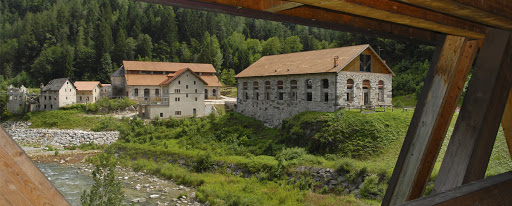 Valle Imperina mining site (photo by Patrizia Cibien)
USEFUL INFORMATION
Near the quarries, in line with the so-called "Peschiere", or "fisheries" there is an area of morainic origin full of erratic boulders. From these massive boulders were extracted stones used for the construction of bridges, like the one in Pontalto and Missiaga.
LINKS TO WEBSITES
BIBLIOGRAPHY
- G. VALLENZASCA, Della falcadina: trattato patologico-clinico... 1840
- D. PERCO (a cura di), Uomini e pietre nella montagna bellunese, Belluno, Provincia, 2002
- D. GIORDANO, Dolomiti di cristallo. Minerali e mineralogia dell'Agordino. GAMP
- R. Vergani, Le miniere di Agordo. Storie di Valle Imperina, 2016
AUTHOR: Letizia Lonzi, 30/04/2020