• Pannello Pale Di San Lucano 001
  • Pannello Pale Di San Lucano 002
  • Pannello Pale Di San Lucano 003
  • Pannello Pale Di San Lucano 004
  • Pannello Pale Di San Lucano 005
  • Pannello Monte Agner 001
  • Pannello Monte Agner 002
  • Pannello Monte Agner 003
  • Pannello Monte Agner 004
  • Pannello Monte Agner 005

The Dolomia Way - The journey of the rock in the Dolomite Alps

THE PROJECT

THE PROJECT

The "Follador-De Rossi" Institute of Higher Education in Agordo (BL) is the project leader of the project "DOLOMIA. The Dolomite Way: the journey of the rock in the Dolomite Alps - ITAT 2036", financed under the second Interreg notice VA Italy-Austria 2014-2020.

Discover

THE INTERACTIVE MAP

THE INTERACTIVE MAP

All the data of the Dolomia project have been geo-referenced and also included in Open Alp Maps, the geo-tourist database of the Agordo's Dolomites.
A map dedicated exclusively to the Dolomia project was also created.

Discover

THE DOLOMIA IN THE LANDSCAPE

THE DOLOMIA IN THE LANDSCAPE

Outcrops

Landslides

Geosites
THE DOLOMIA PROVIDES JOB

THE DOLOMIA PROVIDES JOB

Limekilns

Stone quarries

Mines

Contemporary buildings
THE DOLOMIA IN THE HISTORY

THE DOLOMIA IN THE HISTORY

Archaeological sites

Castles and fortresses

Churches and steeples

Historical centres
Monuments

Fountains

Museums

Boundary stones
ITINERARY OF SAN LUCANO VALLEY

ITINERARY OF SAN LUCANO VALLEY

The San Lucano Valley (Valle di San Lucano) extends for 10 kilometres, passing through the core of one of the greatest dolomitic reefs. Its average depth is almost 2 kilometres and is characterised by a clearly distinguishable glacial profile.

Discover

WATER TRAIL

WATER TRAIL

Water in its various aspects such as streams, springs, waterfalls, lakes, glacial morphology.

Discover

EARTH TRAIL

EARTH TRAIL

Geology, local history and the use of rocks by man.

Discover

FIRE TRAIL

FIRE TRAIL

It develops entirely in the sub-basin of the Bordina stream, inside the outcrop area of the magmatic rocks

Discover

AIR TRAIL

AIR TRAIL

The panoramic views: it takes place along the ridge between the San Lucano and Garés Valleys

Discover

ITINERARY CORPASSA VALLEY - MALGA PELSA

ITINERARY CORPASSA VALLEY - MALGA PELSA

Going up the Val Corpassa up to the Pelsa lagoon, the site of very important fossiliferous finds

Discover

VIDEO

3D MODEL OF MOUNT CIVETTA
Video shot from a helicopter aimed at creating a 3D model of the rocky walls of Mount Civetta.


IMMERSIVE IMAGES

360 PANORAMAS
Piazza di Agordo - foto a 360 gradiAgordo main square: parish church, town hall and Villa Crotta de Manzoni
Veduta da località Tamonich - foto a 360 gradiView of the Agordo mountains from Tamonich, home of the IIS Follador

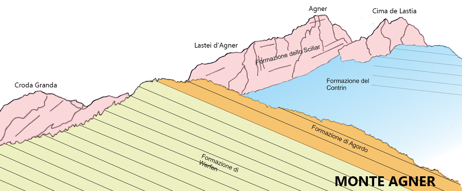
Description of the itinerary

Posted in Itinerary Corpassa Valley - Malga Pelsa

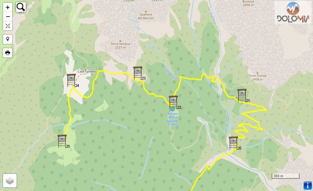
If travelling from Listolade (approx. 680 metres above sea level) Panel 18, it is advisable to continue by car to Capanna Trieste (1105 metres above sea level) Panel 19, as the route might become quite challenging because of the difference in height (roughly 1200 meters); in any case, there are no important geological features here.

Once you reach Capanna Trieste (Panel 19) you can park in the large parking lot.

The complete route - a round trip from Capanna Trieste - takes roughly 5 hours.

19 - Capanna Trieste (1105 m a.s.l.)

Posted in Itinerary Corpassa Valley - Malga Pelsa

Capanna Trieste is located over the wide rocky riverbed, inside an active debris gorge. The surrounding rocks belong to the Schlern Formation, its appearance visibly changed by vegetation: at the top looms the slanting silhouette of Torre Trieste (2458m) with its 800-metre high vertical wall; Cima della Busazza (2894m) is to the left with a wall of 1100 metres and to the right is the edge of Van delle Sasse as well as Cima delle Sasse.

Half of Torre Trieste is carved of Main Dolomite, the lower part of Busazza is composed of dolomite, the top part of Grey Limestones. The Val dei Cantoni still hosts a small glacial valley (el Giazer or Glacier de Gasperi), another glacier-snow covered largely with debris is located on the Van delle Nevere, at the base of the Moiazza.

Torre Trieste and Van delle Sasse from Capanna Trieste (photo DG)Torre Trieste and Van delle Sasse from Capanna Trieste (photo DG)

21 - Val Corpassa, Agnér and Cantoni di Pelsa

Posted in Itinerary Corpassa Valley - Malga Pelsa

From Mussaia one could glimpse at the U-shaped glacier profile of Val Corpassa; the left slope at the foot of Moiazza is covered by an enormous detrital fold affected by spectacular debris flows.

The southern horizon is dominated by Mount Agnèr (2878m); the tilt of its layers is not the result of tectonic movements but was rather chiseled out of the clinostratifications of the cliff escarpment of Pale di San Martino-San Lucano (Schlern Formation). The Cimonega Group with Cime del Piz de Mez, Sass de Mura and Piz de Sagron can be seen further left. To the north lies Torre Trieste with its vertical wall.

Panoramic view southwards from MussaiaPanoramic view southwards from Mussaia: recognisable on the left is the Cimonega Group (Feltrine Alps), on the right the awe-inspiring Agnèr (Schlern Formation) with its clear clinostratifications (photo DG).

24 - Col del Camp (1843 m a.s.l.) - Cassian Dolomite

Posted in Itinerary Corpassa Valley - Malga Pelsa

From the hairpin bend where the road leading to Case Favretti branches off, we come within sight of Col del Camp (privately owned like the rest of the surrounding area) and Torre Venezia, with the landslide detachment niche from November 1917 and recently, 2020.

The landscape on the Civetta-Moiazza Group is quite intriguing, especially in the area around Cantoni del Framont, as it allows us to distinguish the terrace which separates the upper structure (Main Dolomite and Grey Limestones), from the lower one (reef dolomite). Framont is composed almost exclusively of the Schlern Formation and only on its left side as well as the Corno del Framont there is an outcrop of Cassian Dolomite. The Travenanzes Formation, being the sole culprit for the gap in the slope because of its erodibility, is almost completely buried under the scree.

Torre Venezia and the landslide detachment niche from the collapse in 1917, Col del Camp front right (photo DG). Torre Venezia and the landslide detachment niche from the collapse in 1917, Col del Camp front right (photo DG).

PROJECT PARTNERS


universitat innsbruck

UNIVERSITY OF INNSBRUCK


Logo IIS Follador

ISTITUTO DI ISTRUZIONE SUPERIORE
"U. Follador - A. De Rossi"


circolo cultura e stampa bellunese

CIRCOLO CULTURA E STAMPA BELLUNESE